Chennai Map: Navigate the City with Confidences
Chennai, the capital of Tamil Nadu, is a city where history meets modern life. From ancient temples to high-rise tech parks, it's a place that blends tradition and progress. If you're new to the city, a tourist, a student, or looking to buy a home, a Chennai map is the best way to understand how the city is built and how to get around.
Let's explore how you can use a map of Chennai to plan travel, explore areas, and make smart decisions—especially if you're looking at real estate hotspots like Pallavaram and the Pallavaram-Thuraipakkam Road in South Chennai.
Whether printed or digital, a good Chennai city map shows:
- Major roads and highways
- Metro and train stations
- Bus routes
- Tourist landmarks
- IT parks and real estate zones
- Schools, hospitals, and malls
It's useful for everyone—from daily commuters to homebuyers.
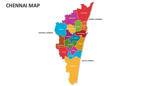
Chennai has four major regions:
- North Chennai: Mostly industrial, with ports and older neighborhoods.
- Central Chennai: Home to government offices, shopping, and business areas like T. Nagar and Egmore.
- West Chennai: Includes fast-developing areas like Porur and Ambattur.
- South Chennai: The city's growth engine, including Pallavaram, OMR, and GST Road.
South Chennai, especially around the Pallavaram-Thuraipakkam Radial Road, is now a top choice for real estate due to IT parks, metro links, and better roads.
- The Blue Line runs from Wimco Nagar to the Airport, with stations like Chennai Airport and St. Thomas Mount.
- Green Line connects Central to St. Thomas Mount.
- Phase 2 (118.9 km) is under construction, with sections like Porur to Poonamallee expected to open soon.
This is pushing property prices up along new metro routes, especially near Radial Road and OMR.
- 12.7 km long, it links GST Road (near the airport) with OMR.
- A new high-level bridge is being built over Pallikaranai marshland to prevent flooding and improve year-round access.
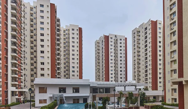
- Prestige Pallavaram Gardens, a major residential project here, is drawing buyers due to excellent connectivity and serene surroundings.
Here are a few locations worth highlighting:
- Temples: Kapaleeshwarar Temple in Mylapore
- Beaches: Marina Beach, Elliot's Beach (Besant Nagar)
- Hospitals: Apollo (Greams Road), MIOT (Manapakkam)
- Universities: Anna University, IIT Madras
- Malls: Phoenix MarketCity, Express Avenue, Forum Vijaya Mall
- Metro Stations: Vadapalani, CMBT, St. Thomas Mount, Airport
These places are important landmarks and help when searching for nearby homes, rentals, or hotels.
For real estate buyers and investors:
- Pallavaram is just 15–20 minutes from the airport.
- 2BHK rents in Pallavaram range from ₹16,000 to ₹35,000/month.
- South Chennai (OMR, Tambaram, Radial Road) shows 8–15% yearly price growth due to metro expansion and new infrastructure.
- Homes near Prestige Pallavaram Gardens offer strong returns and a peaceful lifestyle.
- Google Maps for daily travel and traffic
- CMRL Map for metro routes
- (visit: chennaimetrorail.org for the latest map)
- Real estate portals for viewing properties by area
- CMDA maps for future development plans
It shows growth corridors, Metro lines, and how close homes are to IT parks, schools, and hospitals—helping you spot the best investment areas.
Look for Chennai Airport (Tirusulam), Chennai Central and Egmore railway stations, and Metro hubs like CMBT and St. Thomas Mount.
South Chennai, especially OMR, GST Road, and Pallavaram-Thuraipakkam Radial Road, with new tech parks, better roads, and Metro lines.
Maps often mark top hospitals (like Apollo, MIOT) and universities (like Anna University, IIT Madras) to help families and students.
Whether you're planning your daily commute, finding the best school for your kids, or investing in a home near Prestige Pallavaram Gardens, a Chennai map is more than just directions—it's your personal guide to understanding the city.
Start with a map, and Chennai becomes easier to explore, live in, and invest in.
| Enquiry |


